List of Monuments of National Importance in Trichy circle
This is a list of Monuments of National Importance (ASI) as officially recognized by and available through the website of the Archaeological Survey of India in the Indian state Tamil Nadu. 162 Monuments of National Importance have been recognized by the ASI in Trichy circle of Tamil Nadu.[1][2]
List of monuments
| SL. No. | Description | Location | Address | District | Coordinates | Image |
|---|---|---|---|---|---|---|
| N-TN-T1 | Brihadisvara Temple | Jayankonda Cholapuram | Ariyalur | 11°12′23″N 79°26′56″E / 11.206279767856758°N 79.44889137992311°E |  More images | |
| N-TN-T2 | Jain Statue Built Of Granite ( Moved to museum ) | Jayankonda Cholapuram | Ariyalur |  Upload Photo | ||
| N-TN-T3 | Jain Statue Called Paluppar | Jayankonda Cholapuram | Ariyalur | 11°12′32″N 79°21′54″E / 11.208987301295767°N 79.36503343313437°E | .jpg) More images | |
| N-TN-T4 | Mandapakkadu (Structure With Mound) | Chettipalayam | Coimbatore | 10°56′54″N 77°03′04″E / 10.948365388531693°N 77.0512478573331°E |  More images | |
| N-TN-T5 | Fort on Rock | Dindigul | Dindigul | 10°21′38″N 77°57′47″E / 10.360552510030427°N 77.96309065897138°E |  More images | |
| N-TN-T6 | Dolmens Near Palamalai | Adukkam | Dindigul | 10°12′32″N 77°33′03″E / 10.20881013665242°N 77.5507177977542°E | Upload Photo | |
| N-TN-T7 | Cave In Sitharmalai | Mettupatti | Dindigul | 10°04′28″N 77°50′44″E / 10.074478474684815°N 77.84545576169461°E | Upload Photo | |
| N-TN-T8 | Dolmens Near Machur Reserved Forest | Panaikkadu | Dindigul | 10°16′22″N 77°36′24″E / 10.272783415462776°N 77.60665497965142°E | Upload Photo | |
| N-TN-T9 | Dolmens Near Machur | Panaikkadu | Dindigul | 10°16′11″N 77°32′27″E / 10.269796065537738°N 77.5409161096097°E | Upload Photo | |
| N-TN-T10 | Dolmens Near Talayar River On Top Of The Hill | Panaikkadu | Dindigul | 10°16′02″N 77°30′04″E / 10.267214088369103°N 77.50111456992224°E | Upload Photo | |
| N-TN-T11 | Dolmens | Vilpatti | Dindigul | 10°17′15″N 77°37′45″E / 10.28736220026211°N 77.62917518629637°E | Upload Photo | |
| N-TN-T12 | Rock-amidst Sea where Swami Vivekananda meditated | Kanyakumari | Kanyakumari | 8°04′41″N 77°33′20″E / 8.077955°N 77.555607°E |  More images | |
| N-TN-T13 | Rock cut Cave temple Rock-cut cave temple together with adjacent land in survey plot nos. 2632/8, 2632/9 and 2632/10 | Thirunanthikarai | Kanyakumari | 8°23′55″N 77°17′52″E / 8.398651200442776°N 77.29780379083444°E |  More images | |
| N-TN-T14 | Chitharal Jain Monuments (Bhagavati Temple and Jaina-bas Relief) with adjacent land comprised in part of survey plot no. 4752 | Chithral | Kanyakumari | 8°19′57″N 77°14′19″E / 8.332432809072008°N 77.2387244718233°E |  More images | |
| N-TN-T15 | Vattakottai Fort Vattakottai Forttogether with adjacent area comprised in survey plot nos. 1342, 1344/5 andpart of survey plot nos. 1340/4, 1340/3, 1341/1, 1341/4, 1344/6 and 1343/1 | Vattakottai | Kanyakumari | 8°07′30″N 77°33′54″E / 8.125°N 77.565°E | 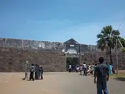 More images | |
| N-TN-T16 | Parthasarathi and Krishna Temples Parthasarathiand Krishna Temples Complextogether with adjacent area comprised in surveyplot nos.535/1, 534/2, 535/10, part of survey plot nos. 534/1, 533/7, 535/8, 533/2, 534/4,533/5, 533/6 and 535/9 | Parthivapuram | Kanyakumari | 8°16′31″N 77°10′16″E / 8.275363822782733°N 77.17122527241403°E |  More images | |
| N-TN-T17 | Rock (Kulithalai) | Vaigainallur | Karur | 10°53′56″N 78°23′20″E / 10.898964102913663°N 78.38890189619205°E | Upload Photo | |
| N-TN-T28 | Kambarmedu | Melaiyur | Mayiladuthurai | 11°02′38″N 79°34′44″E / 11.04378373201533°N 79.57899347911008°E | .jpg) More images | |
| N-TN-T29 | Excavated remains and Buddhist vihara and temple at Pallananesvaram | Melaiyur (Kaveripattinam) | Mayiladuthurai | 11°08′51″N 79°49′50″E / 11.147451833784196°N 79.83052007116439°E | .jpg) More images | |
| N-TN-T30 | Town Gateway | Tranquebar (Tarangambadi) | Mayiladuthurai | 11°01′34″N 79°51′07″E / 11.026084788300858°N 79.85195637398816°E |  More images | |
| N-TN-T18 | Jain Statues, Rock Inscription And Panchapandava Beds On The Hill | Kalluthu | Madurai | 10°04′28″N 77°50′43″E / 10.074450969876217°N 77.84525974954349°E | Upload Photo | |
| N-TN-T19 | Rock Cut Bas Relief And Beds And A Mutilated Jain Stone Image | Karadipatti | Madurai | 9°55′51″N 78°01′24″E / 9.930697596910003°N 78.02320876093526°E |  More images | |
| N-TN-T20 | Rock cut Bas-relief of Jain images with inscriptions in Vattalethu in Ammanamalai or Samanarmalai. | Keelakuilkudy | Madurai | 9°55′20″N 78°02′57″E / 9.922235776815343°N 78.04909207755941°E | 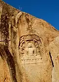 More images | |
| N-TN-T21 | Panchapandava Bed, Jain Statues, And Brahmi And Vatteluttu (Malai Inscription On The Panchapandar) | Kilaiyur Keelavalavu | Madurai | 10°03′49″N 78°24′00″E / 10.06370475258435°N 78.39996930261239°E | _-Jain_Sculptures.JPG) More images | |
| N-TN-T22 | Rock Cut Beds Under Natural Rock Shelter In Amanarmalai Or Samanar Malai | Melakuilkudy | Madurai | 10°03′47″N 78°23′55″E / 10.063045245461945°N 78.39858293886384°E | Upload Photo | |
| N-TN-T23 | Alagarmalai cavern with Panchapandava beds midway between Alagarmalai and Kidanpatti. | Melur | Madurai | 10°04′52″N 78°14′18″E / 10.08123872134608°N 78.23827246408983°E | Upload Photo | |
| N-TN-T24 | Cavern with Panchapandava beds on western slope of the hills and similar beds behind the Sikkandar mosque on the top. | Thiruparankundram | Madurai | 9°52′41″N 78°04′00″E / 9.878068465471356°N 78.06676760823548°E |  More images | |
| N-TN-T25 | Rock–Cut Cave And Inscription | Thiruparankundram | Madurai | 9°52′27″N 78°04′15″E / 9.874030265245846°N 78.0708805932383°E |  More images | |
| N-TN-T26 | Ramapada Mandapam | Kodiakkadu | Nagapattinam | 10°19′56″N 79°50′33″E / 10.332089785783701°N 79.84251224177476°E |  | |
| N-TN-T27 | Inscribed Stone | Kodiyakarai | Nagapattinam | 10°16′29″N 79°48′49″E / 10.274600279069888°N 79.81358356801624°E | Upload Photo
| |
| N-TN-T31 | Group of sculptured dolmens | Banagudi Sholai | Nilgiris | Upload Photo | ||
| N-TN-T32 | Jain Theerthankara Images | Alangudipatti | Pudukkottai | 10°38′24″N 78°48′50″E / 10.64007059938087°N 78.81382936069593°E | Upload Photo | |
| N-TN-T33 | Jain Image | Alathur | Pudukkottai | 10°28′43″N 78°37′13″E / 10.478524608324797°N 78.6203756071698°E | Upload Photo | |
| N-TN-T34 | Dolmens and Cairns | Amburapatti | Pudukkottai | Upload Photo | ||
| N-TN-T35 | Prehistoric Burial Site (Known as Kurangapattarai) | Ammachatram | Pudukkottai | 10°30′19″N 78°47′11″E / 10.505360380596388°N 78.78626260386032°E | _9.JPG) More images | |
| N-TN-T36 | Whole cave with the two Jain figures carved on the rock over it on the eastern side of Aluruttimalai in Ammachatram village and damaged inscription on the northen side of the sloping sheet of the rock below the same cave. | Ammachatram | Pudukkottai | 10°31′34″N 78°46′27″E / 10.526214921484154°N 78.77430164273328°E |  More images | |
| N-TN-T37 | The Whole Of the Siva Temple (Meenakshi Sundareswarar Temple) And The Inscribed Stone In The Front Mandapam | Ammankurichi | Pudukkottai | 10°20′37″N 78°32′04″E / 10.343595655913283°N 78.5343620791101°E | Upload Photo | |
| N-TN-T38 | Prehistoric Burial Site, Stone Circle, and Menheirs | Annavasal | Pudukkottai | 10°26′47″N 78°41′57″E / 10.446341398796287°N 78.69921756962208°E | Upload Photo | |
| N-TN-T39 | Two Jain Tirthankara Images In A Coconut Plantation | Annavasal | Pudukkottai | 10°27′51″N 78°41′46″E / 10.464079706297706°N 78.69601468223263°E |  | |
| N-TN-T40 | Siva Temple | Ariyur | Pudukkottai | 10°25′14″N 78°43′59″E / 10.420436915197506°N 78.73312811770177°E | Upload Photo | |
| N-TN-T41 | Jain Tirthankara Image And Inscribed Stone | Chettipatty | Pudukkottai | 10°39′55″N 78°49′31″E / 10.665411798344742°N 78.82527362589131°E | Upload Photo | |
| N-TN-T42 | Ruined Jain Temple | Chettipatty | Pudukkottai | 10°39′46″N 78°48′59″E / 10.662855452186076°N 78.81648114929193°E | Upload Photo | |
| N-TN-T43 | Sarangatheeswara temple known as Thiruvagneeswarar temple. | Chittur | Pudukkottai | 10°22′03″N 78°41′37″E / 10.36753733386542°N 78.69365749752181°E |  | |
| N-TN-T44 | The dolmens in the right flank of Chokkanatham kanmoi. | Chokkanatha Patti | Pudukkottai | Upload Photo | ||
| N-TN-T45 | Rock-Cut Siva Shrine | Devarmalai | Pudukkottai | 10°21′12″N 78°44′14″E / 10.353420718172954°N 78.73727369197846°E |  More images | |
| N-TN-T46 | Kalabham Udaiyar Temple | Irumbanadu | Pudukkottai | Upload Photo | ||
| N-TN-T47 | Siva Temple (Agastheeswarar Temple) And Lion Pillar | Irumbanadu | Pudukkottai | 10°03′30″N 78°59′16″E / 10.058213421373768°N 78.98764197005374°E | Upload Photo | |
| N-TN-T48 | Soundararaja Perumal Temple | Irumbanadu | Pudukkottai | 10°03′21″N 78°58′53″E / 10.05588934568743°N 78.98135487239416°E | Upload Photo | |
| N-TN-T49 | Stone Idols Of Ganesa And Anjaneya | Irumbanadu | Pudukkottai | Upload Photo | ||
| N-TN-T50 | Jain Thirthankara Idol | Kannangarakudi | Pudukkottai | 10°13′19″N 78°48′06″E / 10.221998559443666°N 78.80178516571699°E | Upload Photo | |
| N-TN-T51 | Jain Image, Stone Lion And Foundations Of A Jain Temple | Kannangudi | Pudukkottai | 10°40′23″N 78°50′21″E / 10.672917715296997°N 78.83920471797568°E | Upload Photo | |
| N-TN-T52 | Balasubrahmanya Temple | Kannanur | Pudukkottai | 10°15′35″N 78°40′53″E / 10.259849905618799°N 78.68148089644428°E |  More images | |
| N-TN-T53 | Dolmens | Kilaiyur | Pudukkottai | Upload Photo | ||
| N-TN-T54 | Uttamadanisvara Temple | Kilattaniyam | Pudukkottai | 10°24′11″N 78°36′45″E / 10.403140898898325°N 78.61238681168155°E |  More images | |
| N-TN-T55 | Ruined Siva Temple | Kilayur(Kaliyapatti) | Pudukkottai | 10°38′45″N 78°53′16″E / 10.645736868391994°N 78.88764564805626°E | %22.JPG) More images | |
| N-TN-T56 | Uttamanathaswamy Temple | Kiranur | Pudukkottai | 10°34′19″N 78°47′03″E / 10.571898625500697°N 78.7841885427314°E |  More images | |
| N-TN-T57 | Mucucundeswara temple and the tank in front of it | Kodumbalur | Pudukkottai | 10°32′40″N 78°30′44″E / 10.544538167247138°N 78.51215602588242°E |  More images | |
| N-TN-T58 | Muvar Koil surrounding sub-Shrines, stone enclosure and stone well on the north-west corner. | Kodumbalur | Pudukkottai | 10°32′30″N 78°31′09″E / 10.541712812026978°N 78.51922980771056°E |  More images | |
| N-TN-T59 | Remains Of Aivar Koil | Kodumbalur | Pudukkottai | 10°32′23″N 78°31′14″E / 10.539658629454°N 78.52060734438007°E | Upload Photo | |
| N-TN-T60 | Remains Of Structural Temples And Antiquities | Kodumbalur | Pudukkottai | Upload Photo | ||
| N-TN-T61 | Cavern on the western side of the Kudumiamalai temple hill. | Kudumiyanmalai | Pudukkottai | 10°24′59″N 78°39′28″E / 10.416456673919852°N 78.65769329868978°E | Upload Photo | |
| N-TN-T62 | Amman Shrine (Akhilandeswari Temple) | Kudumiyanmalai | Pudukkottai | 10°25′00″N 78°39′31″E / 10.416538927564668°N 78.65872617973501°E | 
| |
| N-TN-T63 | Musical Inscription | Kudumiyanmalai | Pudukkottai | 10°24′59″N 78°39′31″E / 10.41629824317822°N 78.65868219826505°E |  | |
| N-TN-T64 | The rock-cut shrine called Melakkovil with mantapam in front. | Kudumiyanmalai | Pudukkottai | 10°24′59″N 78°39′31″E / 10.41630498973099°N 78.6586811919652°E | Upload Photo | |
| N-TN-T65 | The Sikhanathaswami temple. | Kudumiyanmalai | Pudukkottai | 10°24′59″N 78°39′34″E / 10.41646722594364°N 78.65932408174478°E |  More images | |
| N-TN-T66 | Eight Natural Caverns, Jain Idols And Inscriptions In Kudagumalai, Aladiperumal Paraika | Kulathur | Pudukkottai | 10°31′38″N 78°46′47″E / 10.527293966137035°N 78.77979890674447°E | Upload Photo | |
| N-TN-T67 | Ruined Siva Temple (The Iswaran Kovil) | Kulathur | Pudukkottai | 10°33′17″N 78°46′57″E / 10.554756299846087°N 78.78248630457016°E |  | |
| N-TN-T68 | Rock-Cut Cave Siva Temple, Hall of Hundred Pillared Mandapam Or Car Mandapam With Wheels In Front Part Of The Plinth | Kunnandarkoil | Pudukkottai | 10°34′55″N 78°53′52″E / 10.581824062513103°N 78.8978099361751°E |  More images | |
| N-TN-T69 | Jain Idols And Remains Of The Jain Temple | Letchumanpatti | Pudukkottai | 10°37′02″N 78°45′48″E / 10.617250650577619°N 78.76330075525965°E | Upload Photo | |
| N-TN-T70 | Idols In The Southern Bund Of Teppakulam Or Urani | Madarapatti | Pudukkottai | 10°32′08″N 78°31′44″E / 10.535524425306704°N 78.52878971641573°E | Upload Photo | |
| N-TN-T71 | (i) The Jain Theerthankara image in Sighasana posture lying in bas-relief on a slab (ii) The Remains of the temple (iii) The Ganesa image (iv) The Nandi, with the inscriptions on the basement and the surrounding portions in the Karuppar hill. | Mailapatti | Pudukkottai | 10°23′04″N 78°45′07″E / 10.384519790870756°N 78.75185435254645°E | Upload Photo | |
| N-TN-T72 | Two Rock-Cut Siva Shrines On The Eastern And Southern Slopes Of The Hill | Malakkoil (Malaiyakoil) | Pudukkottai | 10°20′07″N 78°42′45″E / 10.335215043728292°N 78.7124641536016°E |  | |
| N-TN-T73 | Rock-cut Siva Temple (Pallava 8th century A.D.).Rock-Cut Siva Temple | Malayadipatti | Pudukkottai | 10°39′14″N 78°53′49″E / 10.65379352575879°N 78.89685714923783°E | 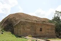 More images | |
| N-TN-T74 | Rock-cut Vishnu cave Temple (Pallava 8-9th century A.D.). Rock-Cut Vishnu Temple | Malayadipatti | Pudukkottai | 10°39′15″N 78°53′48″E / 10.654149381987523°N 78.89665598357573°E |  More images | |
| N-TN-T75 | Jain Temple Site | Mangathevanpatti | Pudukkottai | 10°33′24″N 78°49′20″E / 10.55652784716295°N 78.8221601800067°E |  More images | |
| N-TN-T76 | Ruins of the Jain shrine. | Mangathevanpatti | Pudukkottai | 10°33′24″N 78°49′20″E / 10.556714518975612°N 78.82224442391168°E | Upload Photo | |
| N-TN-T77 | Siva And Pillayar Temple | Mangudi | Pudukkottai | 10°24′52″N 78°42′54″E / 10.41443935894329°N 78.71510260275545°E | Upload Photo | |
| N-TN-T78 | Jain Tirthankara Idol (Aiyanar) And Devi Idols | Marudur | Pudukkottai | 10°34′37″N 78°49′28″E / 10.577051028325215°N 78.82455673268353°E |  More images | |
| N-TN-T79 | Melanilaipatti, Mennandar Pilliar Temple (Mennaanda Moorthi Vinayagar Temple) | Melanilaivayal | Pudukkottai | 10°11′28″N 78°50′38″E / 10.191165286212584°N 78.84390121039505°E | Upload Photo | |
| N-TN-T80 | Prehistoric Burial Site | Melur | Pudukkottai | 10°27′18″N 78°46′23″E / 10.454994554435704°N 78.7731074000247°E | Upload Photo | |
| N-TN-T81 | The Stone circles, Prehistoric burials, slabs Jain Tirthankara idol and the relics of the old Jain temple. | Melur | Pudukkottai | 10°27′21″N 78°46′26″E / 10.455740139232367°N 78.77401974006494°E | Upload Photo | |
| N-TN-T82 | Vishnu Idol | Melur | Pudukkottai | 10°27′17″N 78°46′27″E / 10.454635319945524°N 78.77404163839103°E | Upload Photo | |
| N-TN-T83 | Dolmens | Muttampatti | Pudukkottai | Upload Photo | ||
| N-TN-T84 | The Tirupperumanadar temple called Madattukovil. | Nangupatti (Madattukkoil) | Pudukkottai | 10°34′43″N 78°40′40″E / 10.578552265615402°N 78.67771161506263°E | Upload Photo | |
| N-TN-T85 | Jain idol, inscribed stone slab ,two Durga idols and Vishnu idol. | Nanjur | Pudukkottai | 10°34′45″N 78°48′24″E / 10.57921320875022°N 78.80656874719594°E | Upload Photo | |
| N-TN-T86 | The old burial sites in the three groups | Narangiyan Pettai | Pudukkottai | Upload Photo | ||
| N-TN-T87 | Amman Koil (Melaikadambar Koil And The Siva Temple To Its West) | Narthamalai | Pudukkottai | 10°30′47″N 78°46′03″E / 10.513120585328982°N 78.76742513593406°E |  More images | |
| N-TN-T88 | Rock-cut Siva Temple called Paliyili Iswaran with structural moulded plinth in front. | Narthamalai | Pudukkottai | 10°30′49″N 78°46′04″E / 10.51353699184008°N 78.76764893530519°E |  More images | |
| N-TN-T89 | Rock-cut Vishnu shrine called Samanar Kudagu with structural moulded plinth in front. | Narttamalai | Pudukkottai | 10°30′23″N 78°45′26″E / 10.50645843732222°N 78.75730035227994°E |  More images | |
| N-TN-T90 | Vijayala Choliswaram and the group of Sub-Shrines around it. | Narttamalai | Pudukkottai | 10°30′17″N 78°45′29″E / 10.504777724897384°N 78.7580797059805°E |  More images
| |
| N-TN-T91 | Jain Image And The Inscription To The South Of It On The Summit Of The Sadayaparai | Nathampannai | Pudukkottai | 10°23′19″N 78°47′35″E / 10.38864660253497°N 78.7931179693175°E | Upload Photo | |
| N-TN-T92 | Siva (Valarmadhiswarar) Temple | Nirpalani | Pudukkottai | 10°37′16″N 78°42′39″E / 10.621055537820041°N 78.71086213076751°E |  | |
| N-TN-T93 | Siva Temple | Panangudi | Pudukkottai | 10°26′16″N 78°43′00″E / 10.437692281871032°N 78.71676129419507°E |  | |
| N-TN-T94 | Vishnu Temple | Panangudi | Pudukkottai | 10°26′11″N 78°42′57″E / 10.436430624113026°N 78.71589393218143°E | Upload Photo | |
| N-TN-T95 | The dolmens | Perungulur | Pudukkottai | Upload Photo | ||
| N-TN-T96 | Prehistoric Dolmens | Peyal | Pudukkottai | Upload Photo | ||
| N-TN-T97 | Rajendracolisvaram Temple (Siva Temple) | Ponamaravati | Pudukkottai | 10°16′36″N 78°32′18″E / 10.276766837605381°N 78.53842600067492°E | Upload Photo | |
| N-TN-T98 | Dolmens and Ayyanar Images | Poyyamanai And Virudupatti | Pudukkottai | 10°34′51″N 78°28′02″E / 10.580880782531661°N 78.46723467221791°E | Upload Photo | |
| N-TN-T99 | Jain Theerthankara images now lying in the dry lands to the north-east of Alangudipatti hamlet. | Puliyur | Pudukkottai | 10°38′18″N 78°48′55″E / 10.638470151781469°N 78.81527059962075°E | Upload Photo | |
| N-TN-T100 | Jain Image And The Surrounding Temple Site Locally Called 'Mottai Pillayarkovil' | Puttambur | Pudukkottai | 10°28′11″N 78°50′27″E / 10.469779801158712°N 78.84077804305687°E | Upload Photo | |
| N-TN-T101 | Prehistoric Burial Site | Puttambur | Pudukkottai | Upload Photo | ||
| N-TN-T102 | The Rock-cut shrine called Pushpavaneswara. | Puvalakkudi | Pudukkottai | 10°20′02″N 78°37′33″E / 10.334017800233932°N 78.62586966187331°E |  | |
| N-TN-T103 | Stone Sluice With Nandipottan’s Inscription | Rajalipatti | Pudukkottai | 10°36′44″N 78°28′34″E / 10.612340950365406°N 78.47619303944731°E | Upload Photo | |
| N-TN-T104 | Stone Idols Of Vishnu And Devi And Siva Temple | Rasipuram | Pudukkottai | 10°39′01″N 78°43′20″E / 10.650150665818101°N 78.72231127078497°E | Upload Photo | |
| N-TN-T105 | Prehistoric Burial Site | Satyamangalam | Pudukkottai | Upload Photo | ||
| N-TN-T106 | Jain Mound, Jain Images, Other Idols And Lion Pillars | Sembattur | Pudukkottai | 10°28′53″N 78°50′16″E / 10.481479744697763°N 78.83786509534475°E | Upload Photo | |
| N-TN-T107 | Natural Cavern Called Andarmatam | Sembuthi | Pudukkottai | 10°20′10″N 78°35′19″E / 10.33597484987789°N 78.58870329385529°E | Upload Photo | |
| N-TN-T108 | Cairns and Urns | Sendakudy | Pudukkottai | 10°17′58″N 79°04′40″E / 10.29952025617282°N 79.07784446170339°E | Upload Photo | |
| N-TN-T109 | Dolmens and Urns | Sengalur | Pudukkottai | 10°40′13″N 78°53′06″E / 10.670187513834016°N 78.88487001310615°E |  More images | |
| N-TN-T110 | Vishnu And Sridevi Idols | Sengirai | Pudukkottai | 10°16′21″N 78°52′42″E / 10.272497239229223°N 78.8784719391714°E | Upload Photo | |
| N-TN-T111 | The Bumisvaraswami temple. | Sevalur | Pudukkottai | 10°17′36″N 78°38′00″E / 10.293355687272314°N 78.63333946706153°E | Upload Photo | |
| N-TN-T112 | Rock-cut Jain Temple (Ariver Koil). | Sittannavasal | Pudukkottai | 10°27′21″N 78°43′33″E / 10.455820179541812°N 78.72579699041479°E |  More images | |
| N-TN-T113 | Dolmens in Annavasal Vattam | Sittannavasal | Pudukkottai | 10°26′52″N 78°43′08″E / 10.4478928430402°N 78.71885111432346°E | Upload Photo | |
| N-TN-T114 | Natural Cavern With Stone Beds And Brahmi And Old Tamil Inscriptions Called Enaadipattam | Sittannavasal | Pudukkottai | 10°27′01″N 78°43′30″E / 10.45027054164748°N 78.7250199980587°E |  More images | |
| N-TN-T115 | Tiruvilangudi Siva Temple | Suriyur | Pudukkottai | 10°37′42″N 78°38′16″E / 10.628405048039344°N 78.63771645694831°E | Upload Photo | |
| N-TN-T116 | Dolmens (Known As Kurangupattarai) | Tayinipatti | Pudukkottai | 10°31′36″N 78°45′44″E / 10.526715658049927°N 78.76222320567028°E | Upload Photo | |
| N-TN-T117 | The Jain Theerthankara image seated on a pedestal to the east of the bund of Periakanmoi and to the west of Siva temple. | Tekkatur | Pudukkottai | 10°17′53″N 78°47′14″E / 10.298026812479465°N 78.78710362578265°E |  | |
| N-TN-T118 | Siva Temple | Tennangudi | Pudukkottai | 10°28′23″N 78°51′54″E / 10.472937943079598°N 78.86495284814531°E | Upload Photo | |
| N-TN-T119 | Prehistoric Burial Site | Thekkattur | Pudukkottai | Upload Photo | ||
| N-TN-T120 | The Todaiyur Siva Temple by side of the bundof Todaikulam. | Thodaiyur | Pudukkottai | 10°29′58″N 78°48′32″E / 10.499516392737771°N 78.80877075729657°E |  | |
| N-TN-T121 | The Sanctum of the old Siva Temple. | Tirukalambur | Pudukkottai | 10°12′22″N 78°29′56″E / 10.206047911215895°N 78.49881618795364°E | Upload Photo | |
| N-TN-T122 | Sundareswara Temple with 7 sub-shrines | Tirukkattalai | Pudukkottai | 10°22′11″N 78°51′04″E / 10.369843394954886°N 78.85121469824301°E |  More images | |
| N-TN-T123 | Kalasakkadu Burial Site | Tirukkattalai | Pudukkottai | 10°22′22″N 78°50′31″E / 10.372704805686556°N 78.84195501023348°E | Upload Photo | |
| N-TN-T124 | Rock-Cut Siva Temple (Satyagiriswara Temple) | Tirumayam | Pudukkottai | 10°14′49″N 78°45′06″E / 10.24704573062648°N 78.75179319278097°E |  More images | |
| N-TN-T125 | Rock-Cut Vishnu Temple (Satyamurti Temple) | Tirumayam | Pudukkottai | 10°14′49″N 78°45′07″E / 10.24690007529101°N 78.75198480914388°E |  More images | |
| N-TN-T126 | Stone And Brick Fort (Thirumayam Fort) | Tirumayam | Pudukkottai | 10°14′51″N 78°45′03″E / 10.24761896278593°N 78.75080870533203°E |  | |
| N-TN-T127 | Jain Image In Water spread Of Pudukulam | Tiruppur | Pudukkottai | 10°33′18″N 78°50′44″E / 10.554934507603727°N 78.84553987956104°E | Upload Photo | |
| N-TN-T128 | The Choliswara Udayar temple. | Tiruppur | Pudukkottai | 10°33′23″N 78°50′52″E / 10.556345564096288°N 78.84767179918013°E | Upload Photo | |
| N-TN-T129 | Group of Dolmens | Tiruppur | Pudukkottai | 10°33′28″N 78°50′52″E / 10.557874540443624°N 78.84786327706891°E | Upload Photo | |
| N-TN-T130 | Prehistoric Burial Site | Vadugapatti | Pudukkottai | Upload Photo | ||
| N-TN-T131 | Jain Tirthankara Image And Inscribed Stone | Valavambatti (valavanpatti) | Pudukkottai | 10°33′41″N 78°59′29″E / 10.56136540090587°N 78.99125536665792°E | Upload Photo | |
| N-TN-T132 | Siva Temple (Agatheeswarar Temple) | Varappur | Pudukkottai | 10°27′45″N 78°58′35″E / 10.46240932270065°N 78.97642027829852°E | Upload Photo | |
| N-TN-T133 | The Sivan Koil and its premises on the western of Enadi kanmoi. | Varpet | Pudukkottai | 10°15′55″N 78°31′19″E / 10.26522447252911°N 78.52182818812716°E |  | |
| N-TN-T134 | Prehistoric Burial Site | Vathanna Kurichi | Pudukkottai | Upload Photo | ||
| N-TN-T135 | Jain Tirthankara Image | Veerakkudy | Pudukkottai | 10°32′53″N 78°51′44″E / 10.5479548299227°N 78.86224106133992°E | Upload Photo | |
| N-TN-T136 | Agastisvara Temple | Vellanur | Pudukkottai | 10°27′24″N 78°47′36″E / 10.456600454360025°N 78.79331267518776°E | Upload Photo | |
| N-TN-T137 | Kailasanatha Temple | Vellanur | Pudukkottai | 10°27′22″N 78°47′49″E / 10.456112930191976°N 78.79692910415814°E | Upload Photo | |
| N-TN-T138 | Prehistoric Burial Site | Vilapatti | Pudukkottai | Upload Photo | ||
| N-TN-T139 | The Two lion pillars in the Vahanamantapam attached to the sri Subramanyaswami temple. | Viralimalai | Pudukkottai | 10°36′10″N 78°32′46″E / 10.602784576875171°N 78.54613091489061°E | Upload Photo | |
| N-TN-T140 | Siva Temple | Visalur | Pudukkottai | 10°38′36″N 78°51′56″E / 10.643330148812732°N 78.86543488914924°E |  More images | |
| N-TN-T141 | Boulder Stone Bed And Brahmi Inscriptions On The Hill And Rock-Cut Temple With Inscription At The Foot Of The Hill | Kunnakudi | Sivaganga | 10°06′52″N 78°41′55″E / 10.114563859747818°N 78.69860036218486°E |  More images | |
| N-TN-T142 | Two rock cut temples with inscriptions in Varunachimalai | Thirumalapuram | Tenkasi | 9°04′31″N 77°24′28″E / 9.075272043167635°N 77.4078370085665°E |  More images | |
| N-TN-T143 | Airavatesvara Temple | Chatram Darasuram | Thanjavur | 10°56′54″N 79°21′24″E / 10.94841°N 79.356708°E |  More images
| |
| N-TN-T144 | Big Cannon (Rajagopaol Cannon) In The First Rampart and the Bastions in Ts No 608 Of Ward III | Thanjavur | Thanjavur | 10°47′36″N 79°08′20″E / 10.793450294227014°N 79.13900666455095°E |  More images | |
| N-TN-T145 | Schwartz (Christ) Church in the north-east portion of the little Fort. | Thanjavur | Thanjavur | 10°47′09″N 79°07′53″E / 10.785722°N 79.131284°E |  More images | |
| N-TN-T146 | Sivaganga Little Fort Enclosing The Big Temple | Thanjavur | Thanjavur | 10°47′04″N 79°07′54″E / 10.784552998454394°N 79.13154426165907°E |  More images | |
| N-TN-T147 | Karuppannasvami Rock And Jain Sculpture | Uttamapalayam | Theni | 9°48′43″N 77°19′49″E / 9.812077849297989°N 77.33027083737234°E | Upload Photo | |
| N-TN-T148 | Bhaktavatsala Temple | Seramadevi | Tirunelveli | 8°41′59″N 77°34′16″E / 8.699788644118119°N 77.57115812342622°E |  More images
| |
| N-TN-T149 | Valliswara temple | Tiruvalisvaram | Tirunelveli | 8°44′22″N 77°26′24″E / 8.739425179259134°N 77.43998848518848°E |  More images | |
| N-TN-T150 | Ancient Site | Kunnathur | Tirunelveli | 8°41′50″N 77°40′20″E / 8.69728608711183°N 77.67231479925216°E |  More images | |
| N-TN-T151 | Prehistoric Site | Adichanallur | Thoothukudi | 8°37′57″N 77°52′37″E / 8.632595986381967°N 77.87685979944634°E |  More images | |
| N-TN-T152 | Prehistoric Site | Kalvoi | Thoothukudi | 8°37′44″N 77°52′31″E / 8.628885746344613°N 77.87532126550501°E | Upload Photo | |
| N-TN-T153 | Prehistoric Site | Karungulam | Thoothukudi | 8°37′51″N 77°52′30″E / 8.630874264512045°N 77.87488570864434°E | Upload Photo | |
| N-TN-T154 | Head Sluice Periavoikal alias Nattu vaikal | Musiri | Tiruchirappalli | 10°56′45″N 78°26′27″E / 10.945854194472966°N 78.4409218135254°E | Upload Photo | |
| N-TN-T155 | Rock Fort (i) Path leading to the site in front of the lower cave
| Rock Fort, Trichy | Tiruchirappalli | 10°49′41″N 78°41′50″E / 10.82805784770478°N 78.6971757026787°E |  (i) Path leading to the site in front of the lower cave (ii) Site in front of the lower cave (iii) Lower cave (iv) Path leading to the upper cave (v) Upper cave | |
| N-TN-T156 | Kovil (Korangunatha Temple) | Srinivasanallur | Tiruchirappalli | 10°58′24″N 78°21′45″E / 10.973415577660226°N 78.36238721652008°E |  More images | |
| N-TN-T157 | Fort Gateway | Tiruchirappalli | Tiruchirappalli | 10°49′36″N 78°41′36″E / 10.826595259174736°N 78.69338012098707°E |  More images | |
| N-TN-T158 | Sri Erumbeswaraswami Temple | Tiruverumbur | Tiruchirappalli | 10°47′33″N 78°46′05″E / 10.792598128905281°N 78.76812602031899°E |  More images | |
| N-TN-T159 | Pre-historic sites popularly known as "pandava graves" | Kanyampundi | Tiruppur | 11°07′08″N 77°17′18″E / 11.118914202056317°N 77.28840324287746°E |  More images | |
| N-TN-T160 | Sugrivesvara Temple and Tank | Sircar Periyapalayam | Tiruppur | 11°08′02″N 77°23′56″E / 11.1338°N 77.399°E |  More images | |
| N-TN-T161 | Muruganathasvami Temple | Tirumurugan-poondi | Tiruppur | 11°09′50″N 77°18′41″E / 11.1638°N 77.3115°E |  More images | |
| N-TN-T161 | Tirumal Nayak’s Palace | Srivilliputhur | Virudhunagar | 9°30′28″N 77°37′56″E / 9.50779555616747°N 77.6322660656793°E | Upload Photo |
See also
- List of Monuments of National Importance in India for other Monuments of National Importance in India
- List of State Protected Monuments in Tamil Nadu
Footnotes and references
- ^ "Centrally Protected Monuments/Sites: State-wise and Circle-wise" (PDF). asi.nic.in. Retrieved 26 July 2025.
- ^ "6 New Circles of Archaeological Survey of India created". www.pib.gov.in.
External links
https://bhuvan-app1.nrsc.gov.in/culture_monuments/
https://asichennai.gov.in/downloads/MTS_EXTENT.pdf
https://asichennai.gov.in/downloads/SITE_EXTENT.pdf